Fall 2020
From the Editor
Autumn is here and we are still in the throes of the Covid-19 crisis struggling to cope with the necessary changes to our regular routines and to manage in this new world. As we contend with lives and livelihoods upended or put indefinitely on hold, increasingly many of us are seeking and finding solace in nature.

Fall in the Uwharries (Photo by Meredith Mitchell)
Were it not possible to safely get out in the wild, most of us would quite literally go insane these days.
Preserving the Uwharries - the natural wonderland right here in our own backyard - and improving the Uwharrie Trail for the enjoyment of all people has come to have enhanced meaning and more profound purpose to me in this pandemic. How fortunate we are that the Uwharrie Trail is here for us, that the Uwharrie National Forest and Birkhead Wilderness are here for us, and that the Uwharrie Trailblazers, the US Forest Service, Three Rivers Land Trust, the NC Zoo, and others are collaborating to ensure all these crucial life-affirming natural resources thrive as such into the future. This issue of the newsletter celebrates these heroes with a little history, current updates on their work, and more! Please enjoy.
Kim AndersenFrom the Chair

David Craft, Chair
Uwharrie Trailblazers
Bus Driver
What a summer it has been. Lots of well timed rain and the trails are showing it! Lots of social distancing which means lots of folks on the trails.
We begin our workdays on September 12 and we hope you will join us. We'll remove some significant blow downs in the Walkers Creek area and address erosion on the Robbins Branch Trail. Smaller crews allow us to practice safe working guidelines in the COVID environment.
We want to recognize those with 50 hours of service through 2019 with a trail crew shirt. We're keeping up with hours currently. We hope you can earn a shirt too!


Trail Crew who have logged 50 or more hours of service:
Steve Chase
Don Childrey
David Craft
Gifford Del Grande
Dave Gardener
Drew Jones
Merritt Maness
Jim Plant
Mary Joan Pugh
Stanley Siceloff
Frits Siesling
Marcus West
Joe White
Uwharrie Trailblazers shirts and hats of similar style but different design and color will also be available soon to members, at a reduced price, and the general public.
More on that soon!
Our annual meeting is January 9. Save the date.
Thanks again for your support for our Uwharries!
David CraftFrom Humble Beginnings: The Uwharrie Thru Hike
Crystal Cockman
The Uwharrie Trail Thru Hike is a 4-day and 40-mile backpacking trip on the entirety of the Uwharrie Trail in central North Carolina. It is an incredible event, as this trail has so much to offer and is loved by so many. The event started in 2013 when Three Rivers Land Trust, at that time known by the name The LandTrust for Central NC, had a summer Stanback Intern named Rebecca Schoonover.
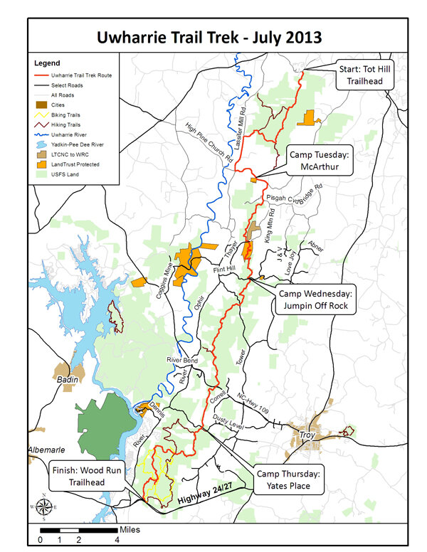
Map from the first thru hike in 2013 (Source: https://ui.uncc.edu/story/uwharrie-trail-end-end)
Rebecca joined us that summer initially to help with an audio tour of the Uwharrie Trail, which was a gathering of stories of important historical, cultural, and natural sites along the trail which we would then record and install QR code signs such that folks who hike the trail could hear the audio and learn about these features. This was inspired by Joe Moffitt, the trail’s original founder, and his book “An Afternoon Hike into the Past,” which offers great information about the trail and its features. The trail is also a great conservation success story, as it always went through some private and some public land, and the land trust has worked to restore lost sections of trail over the past two decades.
Rebecca did indeed do a lot of the research and write up the script for the audio tour, but we learned that her talents also included making entertaining videos of outdoor adventures. She had gone on a trip to South America to climb a 18,000+ foot mountain with a Duke outdoor group and did a great video of the experience. This prompted us to switch her focus to doing a video of a thru hike of our own Uwharrie Trail.
Only Rebecca, Crystal Cockman with TRLT, and Don Childrey, author of the trail guide for the Uwharries, completed the first full 4-day and 40-mile hike, however many other folks joined in for various portions of the trip, around 30 people total, with even more providing trail angel support along the way. This first trip was a true adventure, particularly because we undertook it during the hottest time of the year, the end of July. Rebecca’s internship was just for 11 weeks in the summer, so it was sort of a now or never kind of thing.
We experienced all sorts of great adventures on our hike, including finding a rare orchid I’d been trying to find for about a decade. Rebecca ended up putting together a fantastic video we posted on YouTube, and it was so popular folks starting asking us if they could do the next one with us. At the time, we hadn’t planned on making it an annual event open to the public, and had no idea how popular it would become.
The 2014 and 2015 thru hikes were in May, and in 2016 we switched it to October for cooler weather and hopefully less rain/thunderstorms.

Uwharrie Thru Hike 2019, tents in camp on the evening of Day 3. (Photo by Kim Andersen)
Now in 2020, the thru hike is in its 8th year. We now register just over 100 participants and we open registration in January and it is usually almost full by March. Many folks do the trip year after year and look forward to the reunion with their hiking friends. Some folks have done the hike in memory of a hiking buddy, others have done it for their wedding anniversary. It’s an event that truly has something for everyone. I hope that we’ll be able to continue doing it and getting folks out to enjoy the wonderful trail as long as we can.

Thru hikers 2019 (Photo courtesy of David Craft)
If you’re wondering about the audio trail, we did end up finishing that project with the help of an Eagle Scout, Chris Moncrief. He completed it in 2014 and we just put up new signs this summer (2020) as the old website where it was hosted dissolved. We’re still in the process of getting all the new signs up, but you can listen to the stories on our website at https://threeriverslandtrust.org/ut-audio-tour/. Unfortunately, Rebecca’s video is no longer available on YouTube, but I encourage you to sign up for the thru hike and experience the fun for yourself this year!

New Uwharrie Trail Audio Tour signs installed this year. Thank you to the Three Rivers Land Trust for these wonderful new signs and for maintaining the historic audio tour.
(Photo by Crystal Cockman)
Reflections from the Trail
Yes I am…
Marcus West recounts his epic solo 2-day southbond Uwharrie Trail thru hike just completed in August 2020! All photos by the author unless otherwise noted.

Marcus West, Uwharrie Trailblazer member and trail work veteran, selfie near end of this odyssey, five miles to go!
The comments, “Are you crazy?” and “No way I would!”, were what I heard when I decided to celebrate giving up smoking by going on a 10 mile hike in 2015. Those same comments were what I heard as I prepared to celebrate my 5 year anniversary of that event by attempting a 40 mile thru hike of the Uwharrie Trail in just 2 days. From Tot Hill Trailhead in the Birkhead Wilderness near Asheboro I would hike to the Woodrun Trailhead at US 24/27 west of Troy. Did I mention that I was to do this in August when the heat index sometimes is in the 100° range? Well, let the adventure begin….
August 6, 2020
The prepping for any hike is stressful, but this time I had been packed for several weeks except for food, clothes, and water. Food was easy – 1 dinner, 2 lunches, and several snacks. Water was more than normal – 2.5L. Clothes – all I needed were a change of socks and bed clothes. Prepping complete….well, almost. I thought about my overnight camp and Krista suggested that I stash a cooler and I agreed. So a small cooler with a gallon of water, a couple soft drinks, and a LOT of ice was assembled. Now I was packed and ready. (However, the pack weight of 27.6 lbs was heavy, but after considering that I was hammocking I was OK with it.)
August 7, 2020
The 5:00am alarm sounded signaling the normal time to get up and feed the animals, but I laid in bed thinking of my hike. Around 5:20am I was up and by 6:00am I was ready to get started. I didn’t want to leave before Krista so I hung out until she left for work. By 6:40 I was driving away heading toward my “reward” for staying “quit” from smoking. I stopped and got a breakfast biscuit (routine procedure for going hiking) then within minutes I drove through a light rain shower. I became a little concerned about hiking wet from the very start, but then I smiled and embraced the fact that it would be cooler hiking in the rain.
At my camping destination near Jumping Off Rock I hid the cooler of “trail magic” and hoped it would be there that evening. I rechecked from the road to be sure that it was out of view. With a quick, final peek I drove away and headed toward Tot Hill. Within 20 minutes I pulled into the trailhead parking area.

The Birkhead Wilderness is a beautiful area to explore and hike. There are old gold mines, home places, and cemeteries to be found. The trails are mostly old road beds, which makes hiking enjoyable for most that venture into it. I started my hike by taking a couple of photos which seems to be a mandatory thing with most of my adventures. The first mile went quickly as the trail was especially beautiful that morning due to the light mist hovering in the tree tops which made it seem somewhat enchanted. My backpack finally found its sweet spot as I started across Coolers Knob and I slowed for a few minutes taking in the huge trees lying everywhere on the forest floor. Nature’s power can never be underestimated, but the S.A.W.S. crew did a great job clearing the trail this past year.
Just as I started to pick up my pace I noticed a young couple taking a selfie and remembered that I wanted to take lots of pictures myself. As I passed by the couple I could still smell the campfire smoke on them from their overnight camping. What a wonderful aroma! With a nod and a good morning I continued across the short ridgeline where I met a guy that was doing a short in & out hike which he started before daylight to beat the heat. I did not encounter anyone else until I got to Robbin’s Branch Trailhead. Here I came across a strange site – a white dove standing in the middle of the trail. I smiled and accepted it as a good omen.

I completed the 7 miles through the Birkheads in less than 2.5 hours and was feeling good. That feeling went away as I started the road walk down Lassiter Mill Rd. Traffic was steadily passing and I had to walk in the ditches and right-of-ways that haven’t been mowed since last year. I decided to make the best of it, and thanks to an overcast sky, it was not too hot. Most people drive and never notice the flowers along the roadsides. They are beautiful.

Iron Weed
Finally, I saw the intersection of High Pines Rd, and after 1.5 miles “uphill” I stood in front of the future Walker’s Creek Trailhead, a conserved property that will be a corridor to the Birkheads one day. I paused in gratitude for all the hard work the NC Zoo, Three Rivers Land Trust, the Trailblazers, and many individuals have put forth to make my adventure possible. I then realized that I was hungry! I knew just the spot to have lunch. Thanks to an Eagle Scout project the bench at the Walker’s Creek kiosk made a perfect spot for lunch. I ate, texted Krista to check-in, and enjoyed the beautiful area that was around me. After lunch (with a silent prayer for forgiveness) I decided to continue on the Walker’s Creek section of the future trail instead of doing more road walking to Luther Place.
It didn’t take long before the hot spots on my feet from the road walk started getting worse and just as I crossed Walker’s Creek I sat down to liberally apply anti-chaff cream. I walked about a mile more when I again stopped to rest my feet and drink some much needed water. While resting, I saw one of the highlights of my hike, a juvenile box turtle munching on a mushroom.

King Mountain is known for a climb, but southbound (SOBO) it was a pleasant surprise. The gradual, half mile slope follows an old road bed past an abandon gold mine and was easy compared to the rocky trail heading north. I just wish there had been a “David Craft” bench on top to sit and have a little snack. Next to old Joe Moffitt himself David is one of the greatest stewards of the Uwharrie Trail. I think I will call the steps down to Thayer Road the “Thinking Like Water” crossing, because I helped carry a few of those rocks while David strategically placed them across the road from the Moffitt Trailhead. I stopped to pay tribute to Mr. Moffitt before heading to Little Long Mountain shelter, and for a brief moment I heard “Onward!” as Mrs. Grissom says and the Trailblazers’ slogan suggests.
I passed several hikers coming down Little Long Mountain as I tried to find my fading energy to make it to the top. I pushed harder after a couple of them asked if I was “one of those ultra-runners” after I told them my goal. Little Long Mountain was hot and the lack of shade made me pause for only a quick snack before heading down to Jumping Off Rock for the night.
I was thankful for the hidden cooler of water and beverages because I had become more dehydrated than I realized. It took almost a gallon of water before I felt like setting up camp and cooking. It took even longer, and was much later, before sleep finally befell me.


August 8, 2020
Jumping Off Rock heading south is no joke when your muscles are sore and your feet have major blisters. My calves screamed as I scampered up the rocks of Dark Mountain. I don’t recall much until I reached Panther Branch where a large group of scouts was hanging out. I nodded and before I thought about getting water I had moved on.
The heat started taking a toll on me after that. Heading up Morris Mountain and climbing over several blowdowns had me exhausted by 9 o’clock. It was too early to be so tired. I pushed on….Spencer Creek, done……Climb to US #109, done. Nothing was interesting or memorable because I was in the early stages of heat exhaustion, which I only recognized after reaching Watery Branch. US #109 was busier than normal and I could hear the roaring of tires deep into the woods. After crossing the old road bed (which at one time was the main highway between Montgomery and Stanley counties) I started the slow downward hike to the small creek crossing with steep steps leading to it. I slowed enough to look back at the steps and was glad I was heading south. Those high step ups would have been a strain.

The heat started to take more of a toll as I followed the trail uphill. As I reached the top I slowed from what I thought was a lack of energy. I finished off the last of my cherries and downed the last of one of my liters of water. I felt a little better as I made the decent to Watery Branch. I have always enjoyed this section of trail because it is normally cooler, but this afternoon it was HOT. The lack of breeze didn’t help with cooling or keeping the swarms of gnats from irritating me.
I looked at my watch and knew that I was on schedule with only a mile to Dusty Level Road and then the final stretch in the Woodrun section. I was loving it! That was short lived.
The slow climb up to Dusty Level Rd. drained the last of my reserves. I was feeling light headed and almost called it quits. I have heard it said that the trail always provides. I drank 1/3 of another liter of water and had to relieve myself. I walked back into the trees, and after not seeing anyone since the boy scouts many hours earlier, no sooner did I unzip than I heard voices. Just my luck…three female hikers coming up the trail behind me. I zipped up, threw on my pack, and hiked almost as fast as I had at the start of this adventure. Normally I would have just run down the trail and found another tree but I had to hike past the intersection with Dutchman Creek Tail before the girls finally decided to turn off instead of continuing behind me. I couldn’t wait any longer. I found a small pine tree and helped my situation.
That encounter had pushed me past my bailout point by a couple of miles and with only 6.5 miles to go I trudged on.
Getting low on water when it’s extremely hot is scary, so when I crossed a small trickling stream I filled my reserve bag with 2.5 liters and both my water bottles. I also drank a whole liter before I moved on.
The “X” as I call it, is the crossing of the Uwharrie Trail and Dutchman Creek Trail and it is a very popular break area. More water and a snack of tuna and chocolate was in store for me. I sat down and felt almost sick. I knew that I was suffering from slight heat exhaustion. I took an extra-long break and poured water over my head to cool down. About 15 minutes later I was able to eat some chocolate, but no tuna. I texted Krista and told her to plan on picking me up in 2 and half hours, which meant I had to hike at a pace of 30 minutes per mile. I could do that!

I slowed at every mud puddle, wetting my hat and bandana to help keep my core temperature down. I wasn’t going to let the trail beat me again as it had 5 years earlier. Then I hit the climb up Dennis Mountain. I remembered that climb from the Uwharrie Marathon and Goldrush 50K runs. It was no different this time. It kicked my rear, but after stopping several times I was over it.
I drank more water and hiked on to Keyauwee Bike Trail where I used my reserve water to cool off and refill my empty water bottles.
Three miles is nothing, but on this August afternoon it was a long way to go. I bent over and leaned on my trekking poles and saw a small rock in a heart shape. My mind came back and my love for the trail crept into my heart again. A few yards later I saw another heart shaped rock and I began to push a little harder. Looking down to keep from tripping when you are tired is normal so I studied the roots, rocks, and terrain. I heard a noise and looked up to see my rock and heart almost running down the trail toward me. Krista had come early and hiked in 2.7 miles to hike out with me.

After a brief stop, and a lot of cold water that she had brought, I was ready to finish. The last miles were the best, but the most difficult. Krista took my pack, but after carrying it all day my back fought back. I must have been crazy to want to carry the weight but it felt so strange not having it.
The sound of cars on Hwy 24/27 was a type of finishing bell. It made me push a little harder until in front of me I saw the parking lot emerge. I could barely smile, but inside I was elated and jumping up and down.
Krista gave me my last bit of “trail magic” in the form of a cold Pepsi. She had brought clothes which she encouraged me to change into but I was too beat. I just climbed into the Jeep for the ride home.

(Photo by Krista Andersen)
August 9, 2020
Unpacking my pack I found that I had double packed clothes. There was a bag with cold weather clothing in the bottom of my pack that added at least a pound and a half of weight. Also, I had carried extra hammock accessories that I didn’t need either…. another pound! Lesson learned – always pack and then repack.
I also found out why Krista wanted me to change clothes. I STUNK!!!! She had to deodorize the Jeep seat every day for almost a week to get the “hiker smell” out.
I am thankful for the Uwharrie Trail for challenging me but the real thanks go to the people that made my trip possible. The scouts, Joe Moffitt, David Craft and the Trailblazers, the USFS, and many more. I am thankful for my family for pushing me to quit smoking and for Krista for being the best trail magic I have ever found in the Uwharrie’s.
So to answer everyone’s question ….“Are you crazy?”….Yes I am (and I will do it again)!

Even leaves can be a flower.
— Marcus West, 2020 SOBO Thru Hike
Trail Updates
Trail Adoption Orientation
Jim Plant
The Uwharrie Trailblazers rolled out their trail adoption program earlier this year. The kick-off was delayed due to the pandemic's restrictions. Volunteer work in the National Forest was not allowed for a couple months. Finally, that restriction was lifted, and we are back working on trails!
The club signed a trail adoption agreement with the forest service, adopting all hiking trails in the forest. We divided them up into 18 sections and asked members to adopt them. As of June 20, 2020, we have 17 of the 18 adopted, thanks to a great group of volunteers. Some are long time members and others just joining.

Social distancing circle during the Trail Adoption Orientation. (Photo by Mary Joan Pugh)
June 20, 2020, was our orientation event, held at the future Walker Creek Trailhead. Earlier in the week, we had the area mowed since it was waist high and not conducive for such a gathering. We limited the number to under 20 (we had 19) and we established a 10 foot physical distancing guideline. Everyone showed up with face masks. Mine was dangling from my ear during the presentation.
David Craft kicked things off, asking everyone to say a bit about themselves, where they lived and how they get involved. We had adopters from Angier to Greensboro to Charlotte and places between. Some are military veterans, several are involved with scouting, one adopting team is a Christian fathers and sons group, a tax specialist, a cowgirl (maybe that should be an equestrian), a couple of textile guys. an insurance man - and everyone is volunteer minded.
After introductions, I gave an overview of the adoption program. Dave Gardener lectured on trail safety. Finally, Gifford Del Grande showed off some brand new tools and how to use them.

Gifford shows us how to use an ax. (Photo by David Craft)
A short question and answer period added some good discussion. The painted trail blaze vs plastic "reassurance marker" subject was covered. When is the "gap" going to be closed. No definitive answer to that one. Can we use battery operated tools in the Wilderness? No. Seemingly, we covered it all except for the raging Bigfoot controversy. Dave failed to add that to his safety commentary. Just be mindful out in the forest. Especially if you carry candy bars. Bigfoot has a big sweet tooth for Zagat bars.
Then we headed to the forest. Dave Gardener led a session on lopping. You may wonder why a session on lopping. There is more to it than you think. First off, you need a good lopper. Friskers is the brand of choice for the UTB work crew. Snip branches near the main stem or trunk of the tree to prevent a repeat cut for this season. Cut as if you are carrying a 4x8 piece of plywood through the forest. However, the first couple feet from the ground can be a narrower swath. And those pine trees don't grow back if you cut them at ground level, but other trees do.

Working on a run out during the rail Adoption Orientation. (Photo by David Craft
Gifford Del Grande led the other break out group. He demonstrated how to construct a run out. Once you know how it is constructed, you are better able to clear and repair one. Above, the guys and gals are embedding rocks on the lower side of the run out. Then packing soil on it.
Thanks to all our adopters who were able to make the orientation. It really felt like a community of kindred spirits.
New Land Acquisitions Along the Uwharrie Trail
Crystal Cockman
Three Rivers Land Trust has worked with other conservation partners for about the last two decades trying to reconnect the full 40-mile historic Uwharrie Trail. It always went through some private and some public land, as the founder Joe Moffitt had handshake agreements with private landowners for the trail to go through their properties. As those landowners passed away and left land to heirs or sold land off, sections of the trail closed. Until about 2013, only the first 20 miles of the trail from Highway 24/27 to Jumping Off Rock were open to the public.
The Land Trust has worked with the USFS and other conservation partners, including the NC Zoo, to fill gaps in the trail, including the Klaussner tract near Tot Hill, the King Mountain Property, and the Little Long Mountain property, all of which are now owned by the USFS.

Trail sign at King Mountain. (Photo courtesy of Jared Byrd)
More recently, Three Rivers Land Trust acquired the Dark Mountain or Smith Property, which has a small portion of the trail on it and the peak of Dark Mountain just south of Jumpin Off Rock, and the Dassow Property which has about a ½ mile segment of the trail just south of Tot Hill.
In 2011, Three Rivers Land Trust was contacted by Andy McArthur, who owned a great 45-acre property in the largest gap, between the Walkers Creek USFS area and the southern end of the Birkhead Wilderness. This property also has a great field that has a very scenic vista of the Uwharrie Mountains in the distance. In 2012, the NC Zoo Society acquired that tract and has been holding it to transfer to USFS. They had just that year received an endowment bequest which specified the funds go to protecting wildlife habitat, and thanks to the leadership of Mary Joan Pugh and Gin Wall and Nell Allen, the Zoo Society agreed to purchase that property.

Map showing the current official Uwharrie Trail route (solid red line) at the point where the gap exists. A 5.1 mile road walk is required to get from the existing Uwharrie Trail to the Birkhead Wilderness. In the very near future, the Walkers Creek Trailhead is expected to open and will allow the official trail to then follow the route denoted in this map by the broken red line. When the Walkers Creek Trailhead opens, the resulting change to the trail route will eliminate 1.8 miles of the current road walk! (Image courtesy of Jared Byrd)
In 2015, Three Rivers Land Trust acquired the 7-acre Sykes Property, across the road from the McArthur property. Trail was built by two Eagle Scouts on the Sykes and McArthur Properties before they would transfer to USFS. Also, Amy Grissom donated about 3 acres that made the connection between McArthur and USFS to the south. TRTL’s Sykes property recently became the newest addition to the Uwharrie National Forest as it was acquired by USFS in July 2020. The McArthur property is set to transfer to USFS likely by Fall 2020.

Trail sign directing hikers to new route made possible by new land acquisition. (Photo by Mary Joan Pugh)
Two additional properties north of the Sykes land have been acquired by friends of the Uwharrie Trail, and that puts us just one property away from having the entire trail reconnected. Until that time, the Uwharrie Trail Thru Hike has a section in the middle of about 2 miles that must be walked on roads to bypass the private ownership. That landowner is interested in doing a swap for another USFS property that adjoins them, but the current status of the USFS is that they do not do swaps. However, we are confident we will eventually work something out to have a fully reconnected Uwharrie Trail, with the support of all those who love and hike the trail on a regular basis.
Three Rivers Land Trust Hosts UT Ribbon Cutting
Mary Joan Pugh
Three Rivers Land Trust hosted a Ribbon Cutting on August 14 for Mill Creek/Sykes property recently acquired by the USFS from TRLT for the Uwharrie Trail. Located across High Pine Church Rd from the future Walker’s Creek Trailhead, this tract marks the start of closing the fourth and final gap in the 20-mile Uwharrie Trail section in Randolph County.

Travis Morehead, Executive Director for Three Rivers Land Trust, speaking prior to cutting the ribbon. (Photo by Mary Joan Pugh)
In attendance were USFS Interim District Ranger Chris Stewart and Recreation Staff Officer Theresa Savery; TRLT President West Hunter, Executive Director Travis Morehead, Director of Conservation Crystal Cockman and others; and representatives from US Senators Richard Burr and Thom Tillis and US Congressman Ted Budd. All praised the acquisition and the passage of the Great American Outdoors Act which fully funds ($900 million) the Land and Water Conservation Fund which the USFS and NPS use to purchase conservation land.
At the same time, it is a preview of filling the third gap which is expected this Fall when the USFS purchases the Walker’s Creek property from the North Carolina Zoo. The Uwharrie Trailblazers have constructed a 2.5-mile trail connecting the Walker’s Creek to the existing UT so when the purchase is complete, the Trailhead can open almost immediately.
Be sure to thank:
Three Rivers Land Trust for acquiring the Mill Creek/Sykes, paying for the archeological studies for the trail from its UTB account and maintaining it until the USFS could purchase it.
North Carolina Zoo for purchasing the Walker’s Creek property with donor funds in 2012, allowing the UTB to build a trail and use it for the Thru Hike and preparing it for the USFS to purchase including surveys and structures removal.
UTB for building the 2.5-mile trail connector to the UT.
Next up is closing the fourth and final gap from Walker’s Creek on High Pine Church Rd to the southern boundary of the Birkhead Wilderness. Currently, the owners of all but one tract are ready to sell property for the trail corridor. The Uwharrie Trailblazers are working with the owners of two tracts. Either tract will complete the gap and the 20 miles of UT in Randolph County. No more road walking!

Just after the ribbon was officially cut! (Photo by Mary Joan Pugh)
Flora and fauna along the trail
Finding the exceptional in the ordinary: Goldenrod galls
Ruth Ann Grissom

A Goldenrod Gall. (Photo courtesy of Ruth Ann Grissom)
Mama has a knack for finding four-leaf clovers. We’ll be strolling along, chatting, and she’ll stoop down and pluck one. She doesn’t break stride to stop and search – they just jump out at her.
She doesn’t focus on finding the oddity. Instead, she takes in the sameness of the masses until something different catches her eye.
I’ve tried her approach, but I still fail miserably with four-leaf clovers. I guess I didn’t inherit the luck of the Irish. But I have trained my eye to pick out goldenrod galls among the millions of stems in our early successional habitat in the Uwharries, roughly halfway between Charlotte and Raleigh.
Our stands of native warm-season grasses are riddled with wildflowers (also known as forbs or herbaceous perennials) such as tickseeds (Coreopsis sp.), sunflowers (Helianthus sp.) and goldenrods (Solidago sp.). The goldenrods maintain an elegant presence long after their late blooms have faded, especially when their seedheads are backlit by a low winter sun. Once their withered leaves have dropped, the bare stems make it easy to spot intriguing knots called galls.

Goldenrod seed heads in the fall. (Photo courtesy of Ruth Ann Grissom)
The goldenrod gall fly (Eurosta solidaginis) is responsible for creating these round, marble-sized balls. The female deposits her eggs in spring when the stem is tender and green. The larvae quickly hatch and munch their way into the stalk. Their saliva contains enzymes that stimulate plant growth, forming the thickened mass. The larva holes up for the winter, snug in its case.
If all goes according to plan, the larva will pupate in spring and emerge from the gall. According to Jon Storm, biologist at USC Upstate and keeper of the outstanding Southern Piedmont Natural History page, it does so by inflating a balloon-like structure on its head. This opens the outer layer of a tunnel the larva partially excavated before the gall dried and hardened.
Of course, clever predators have devised ways to access these protein packets. A parasitoid wasp sometimes deposits an egg in the same gall. When the fly larva pupates, the developing wasp eats it. (The wasp is a parasitoid because true parasites don’t kill their host.) Birds, notably chickadees and downy woodpeckers, attack the galls from the outside. The gall proves no match for their beaks.
Studies have shown that wasps tend to select smaller galls, while birds prefer larger ones. The relative size of the galls present in a given area can be an indicator of which predator is more prevalent.
Less frequently, I find elongated galls. These are produced by the goldenrod gall moth (Gnorimoschema gallaesolidaginis). Renowned Piedmont naturalist and bird bander Bill Hilton Jr. wryly notes that its scientific name is “quite a bit longer than its body.”
The moths lay their eggs in the fall, and they overwinter on a protected lower leaf. The eggs hatch in spring as new growth emerges, and larvae enter the stalk. They pupate over summer and emerge as adults in fall, leaving behind empty chambers that can then be occupied by small spiders and insects.
Both species depend on a full year to complete their life cycle, so they can’t survive in fields that are mowed or burned on an annual basis. Our land management likely impacts their populations more than songbirds or wasps.
I don’t see these creatures in the field we burn every year, but there’s very little goldenrod in there. (It has become an almost pure stand of big bluestem, but I’m glad to report that patches of common milkweed seem to be thriving.)
We burn our other fields on longer rotations – every two to five years. Based on my casual observations, the galls seem to cluster in different areas from year to year. Perhaps that has something to do with our management. I imagine we’re both helping the populations of goldenrod gall flies and moths, but also keeping them in check.
It’s a reminder that we are an inextricable part of nature, and our actions have consequences. To fully appreciate that, the first step is to pay attention, taking in the mundane and remaining open to the exceptional.
(NOTE: Ruth Ann Grissom’s above article was first published in January 2020 by the UNCC Urban Institute.)
USFS News
Farewell, Mike Spisak!

Mike Spisak shortly after his arrival in the Uwharries (Photo Courtesy of The Courier-Tribune)
Mike Spisak was the USFS District Ranger for the Uwharrie National Forest from early 2017 until just this summer when he was promoted into a new USFS position on the west coast. Mike’s time here was relatively short, but his impact was great. Mike was the one who pushed to get us chainsaw and crosscut certified. He was also the one that got SAWS to come to the Uwharries (the Uwharries are outside the territory SAWS covers) and that is huge! Without that, we'd still have the blowdowns in the Birkheads. Mike recognized the value in volunteer groups, and he promoted collaboration between UTB and the Forest Service. He got the Betty McGee bridge in the budget. He got a crew to clear through the storm damage on BMT outside the wilderness and got SAWS to clear all trails in the wilderness. He supported our Uwharrie Trailblazers activities by attending several trail celebrations and our annual meeting, speaking at all of them. We will miss him here in the Uwharries but are happy he will have the humidity of the Pacific Northwest if nothing else to remind him of his time in North Carolina!
Mike recently wrote to us from his new assignment:
I hope you are all doing well. We have settled well in our temporary quarters. I’m getting settled into my new position as the Assistant Director in Natural Resources – Forest Products and Vegetation Management in Portland OR. Instead of working with one district / forest I support all the forests in Washington and Oregon. I don’t have the same opportunities to work with volunteers and partners, so I will definitely miss that part of being a District Ranger. We are still house searching. Portland is a really tough market right now and we miss NC affordable housing. It has been a big change in climate for us. Summers here are hot, but things still cool down at night. I’ve had to wear a sweatshirt a couple times … very strange considering it is August. We have visited the Mt. Hood NF, about an hour east of Portland, and enjoyed a hike. I’ve attached a photo. Family is doing well, kids are registered for school. Our daughter Sophia decided to move to Portland with us instead of going to NC State. She is enrolled in a local community college and plans to transfer to a four year college in a year or two. Sonja and I will be happy to find a new home and get settled. I miss working with the Uwharrie Trailblazers. It’s amazing what you have all been able to accomplish over the years. I have no doubt that there will be more great news coming from the Uwharrie…including final connection of the Uwharrie Trail. Thank you for being so kind to me and my family during our time in NC. Please keep in touch!

Mike Spisak and a Douglas Fir (Photo by Mike Spisak)
The Uwharrie Trailblazers wish Mike well in all his future endeavors!!!
Uwharrie National Forest ranger duties have been taken over temporarily by Acting District Ranger Chris Stewart and we look forward to continuing to work with him and the rest of the dedicated staff at the USFS to improve and expand the Uwharrie Trail.
Onwards!
Spotlight
Merrit Maness
Karen Auman
I first met Merrit at a Uwharrie Trail workday. I was new and clueless; Merrit was a kind and a veteran trailblazer. He has hiked portions of the Appalachian Trail, completing a thru hike in sections from 2010-2015. Merrit cares. He cares about our trails and he cares about people. His wife got hurt on the Joe Moffitt TH and he cared for her. He cares about the UT.

Merrit Maness on a trail work day in 2019 (Photo courtesy of Karen Auman)
Merrit Maness got involved with Uwharrie Trailblazers hiking club in 2015 after getting to Luther Place thru hiking the Uwharrie Trail and not knowing a road walk was involved. Upon learning about the road walking, he called the land trust, and they told him to call David Craft. David gave him directions and also told him about work days and the efforts to complete the gap so there would eventually be no need for road walking, and the rest as they say is history. Merrit was “all in” and fully invested in working to make the dreams for the Uwharrie Trail realities!
Merrit’s contributions to the club and the trail are many. He provides fire wood for thru hike. He has been maintaining the north side of Little Long Mountain and the shelter there for four years! He has also cleaned out the spring on Little Long Mountain. And he has lent his skills, strength, and good nature to countless work day projects up and down the trail wherever needed consistently logging more trail work hours per year than anyone but Dave Gardener!
When asked how he became interested in the outdoor life, Merrit said, “I did day hikes with my dad when growing up and also went to look for arrow heads with him, and he taught me to love nature.”
I don't know how many cords of wood he has cut and split so the Thru Hike can have campfires at each campsite. Merrit, I respect you and your blue jacket.

Merrit, center (and minus his blue jacket) with Stanley Siceloff (in the yellow hat) and others working hard on the Uwharrie Trail in 2015 (Photo courtesy of Marcus West)
editorial policy
The contents of this newsletter are authored collaboratively by the Uwharrie Trailblazers steering committee unless otherwise attributed and are intended to illuminate, educate, and inspire all who enjoy the trails of the Uwharries. The newsletter is edited by Uwharrie Trailblazers club secretary Kim Andersen. We welcome suggestions and questions from all readers.
Please send feedback and questions via email to uwharrietrailblazers@gmail.com and visit us on Facebook!